Glorious Gardens: Stonebyres Castle and Estate

Not all gone

Filed under History & Archaeology

- Ruth Thomas, Glorious Gardens volunteer

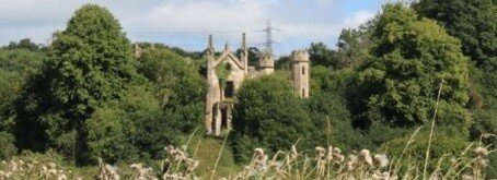
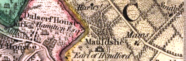
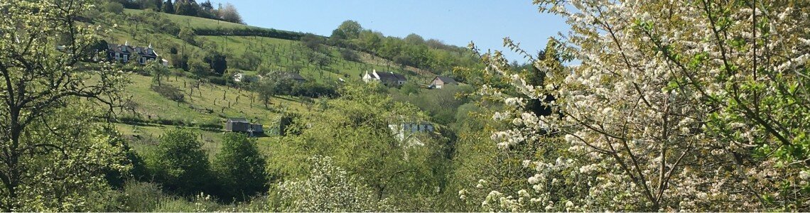
These days, if you notice Stonebyres at all it might be as you drive past an entrance lodge or perhaps wonder about the distinctive grid layout of fields if you looked at a map. There is, though, much more to this old estate which dated back to the 14th century and if you take the time to wander about the estate you would find the remnants of a grand estate, once one of the largest in the area.

  • Pont’s 16th Century map shows Stonebyres as a tower with turrets (highlighted in yellow)

    Pont’s 16th Century map shows Stonebyres as a tower with turrets (highlighted in yellow)

  • Roy’s 1750s of Stonebyres map shows gardens, parkland and woods with the main road running through the estate

    Roy’s 1750s of Stonebyres map shows gardens, parkland and woods with the main road running through the estate

  • The 1859 OS map was the first to be accurately surveyed

    The 1859 OS map was the first to be accurately surveyed

  • The 1911 OS map shows the house and garden during the the final design phase

    The 1911 OS map shows the house and garden during the the final design phase

  • The estate in 1941 after the demolition of the house and the creation of the holdings

    The estate in 1941 after the demolition of the house and the creation of the holdings

  • Pont’s 16th Century map shows Stonebyres as a tower with turrets (highlighted in yellow)
  • Roy’s 1750s of Stonebyres map shows gardens, parkland and woods with the main road running through the estate
  • The 1859 OS map was the first to be accurately surveyed
  • The 1911 OS map shows the house and garden during the the final design phase
  • The estate in 1941 after the demolition of the house and the creation of the holdings

From a fortified castle in the 14th century, Stonebyres House was gradually modified over the centuries to a large mansion. In the 1840s, the profligate lifestyle of the owner led to the sale of the house which was then greatly modified and was surrounded by a designed landscape with four entrance lodges, drives, avenues, parkland with specimen and woodland. The estate had a walled garden, smithy, coach house, laundry, ice house, gasworks, man-made loch used for curling in the winter, quarry and its own water supply.

  • These arches, under Stonebyres House, looked out over Stonebyres Burn

    These arches, under Stonebyres House, looked out over Stonebyres Burn

  • All that remains of the gardens today are the foundations of garden walls and massively overgrown yew hedging

    All that remains of the gardens today are the foundations of garden walls and massively overgrown yew hedging

  • The old balustraded bridge over Stonebyres Burn still stands

    The old balustraded bridge over Stonebyres Burn still stands

  • The remains of the coat of arms from Stonebyres House still lie in the garden

    The remains of the coat of arms from Stonebyres House still lie in the garden

  • Parts of Stonebyres House which were below ground escaped demolition

    Parts of Stonebyres House which were below ground escaped demolition

  • This stone-built barrel vaulted water tank, at least 150 years old is still intact

    This stone-built barrel vaulted water tank, at least 150 years old is still intact

  • Stonebyres Burn was landscaped with walls and riverside walks

    Stonebyres Burn was landscaped with walls and riverside walks

  • These arches, under Stonebyres House, looked out over Stonebyres Burn
  • All that remains of the gardens today are the foundations of garden walls and massively overgrown yew hedging
  • The old balustraded bridge over Stonebyres Burn still stands
  • The remains of the coat of arms from Stonebyres House still lie in the garden
  • Parts of Stonebyres House which were below ground escaped demolition
  • This stone-built barrel vaulted water tank, at least 150 years old is still intact
  • Stonebyres Burn was landscaped with walls and riverside walks

There was another major renovation of the house in 1906. When the owner died in 1933 the house was demolished and the land sold to the Department of Agriculture who created small holdings for unemployed men from Auchenheath.  Elements of the old estate and the designed landscape exist today. Watch the videos below for journeys through what remains of the Estate today.

This is the drive from the lodge in the North West of the Stonebyres estate (Grid Ref NS 8392 4437) to the site of Stonebyres House (Grid Ref NS8408 4389).

This video follows the route of the old east-west road that runs through the estate. The video starts at the crossroads at the centre of the estate (Grid Ref NS 8402 4372) and finishes at the point where the road is no longer visible on the flanks of Black Hill (Grid Ref NS 8333 4417).

The video follows the track from the site of Stonebyres House (Grid Ref NS8408 4328) to the Coach House and Stables (Grid ref NS 8415 4362).

To find out what remains, why not read the report under ‘Related Resources’, and then perhaps take stroll round Stonebyres to get a flavor of the old estate?

This research was carried out as part of the Glorious Gardens volunteer project, which is managed by Scotland's Garden & Landscape Heritage and delivered by Northlight Heritage, with funding from the Heritage Lottery Fund supported Clyde and Avon Valley Landscape Partnership and from Historic Environment Scotland.  To find out more about the project, explore the other museum items below.


You Might Also Like...


Glorious Gardens: The Kerse

Glorious Gardens: The Kerse

Still a pleasure walk today

Glorious Gardens: Jerviswood

Glorious Gardens: Jerviswood

A beautiful and productive landscape on the outskirts of Lanark

Glorious Gardens: Harperfield

Glorious Gardens: Harperfield

A country house - with lions

Glorious Gardens: Cleghorn Estate

Glorious Gardens: Cleghorn Estate

A landscape of magnificent trees

Glorious Gardens: Cambusnethan

Glorious Gardens: Cambusnethan

A disappearing treasure of the Clyde Valley

Glorious Gardens: Baronald House

Glorious Gardens: Baronald House

The Echo in the Crags and the Botanist

Glorious Gardens: Mauldslie Castle

Glorious Gardens: Mauldslie Castle

One of the Valleys' grandest old estates

Shaping the Landscape: Black Hill and Stonebyres Quarry

Shaping the Landscape: Black Hill and Stonebyres Quarry

Hill formed from cooling magma providing great geological look out

Shaping the Landscape: Stonebyres Falls

Shaping the Landscape: Stonebyres Falls

Giant rock steps over which the Clyde tumbles

The Clyde Walkway Stage 4: Cardies Bridge to Crossford

The Clyde Walkway Stage 4: Cardies Bridge to Crossford

Through historic woodlands and agricultural landscape to Crossford village.

The Clyde Walkway Stage 5: Crossford to Falls of Clyde, New Lanark

The Clyde Walkway Stage 5: Crossford to Falls of Clyde, New Lanark

Orchard country, spectacular wooded gorges and New Lanark UNESCO World Heritage Village

Low Parks Museum, Hamilton

Low Parks Museum, Hamilton

Low Parks Museum in Hamilton is a 5-star museum under the Visit Scotland grading scheme, situated in the former Low Parks of the Duke of Hamilton's estates.

Scotland's Garden and Landscape Heritage

Scotland's Garden and Landscape Heritage

Encouraging the protection and study of historic parks, gardens and designed landscapes

Northlight Heritage

Northlight Heritage

Making Heritage Matter

The valley of the glasshouses

The valley of the glasshouses

From Hot Houses to Garden Centres

The Royal Burgh of Lanark Museum

The Royal Burgh of Lanark Museum

A collection of items illustrating the ancient and varied history of the ancient Royal Burgh.

The Leadhills & Wanlockhead Railway

The Leadhills & Wanlockhead Railway

Explore the lead mining museum at Wanlockhead and marvel at the skills of the lead miners who dug their shafts to below sea level and excavated miles of tunnels in their search for lead ore and silver.

The industrial valleys

The industrial valleys

Industry in the Clyde and Avon Valleys

Tasting Through Time

Tasting Through Time

Historic apple, plum and pear recipes

MapCRAFT

MapCRAFT

Expressive Mapping in the Clyde and Avon Valley

Making a Medieval Tile

Making a Medieval Tile

Celebrating the Brick and Tile Industry of the Clyde and Avon Valley

Shaping the Landscape: Thank the Rocks for the Trains

Shaping the Landscape: Thank the Rocks for the Trains

How geology led to the first local train lines

Shaping the Landscape: The Falls of Clyde

Shaping the Landscape: The Falls of Clyde

Dramatic falls show the power of ancient glaciers